Maryvale Coal Project
Introduction
Kaili’s Queensland coal tenements are situated 30 km north of Warwick within the
Darling Downs region of south Queensland. The tenements are adjacent to a railway line that connects Warwick to Toowoomba in the north and then to the capital city of Brisbane (190 km) from where the coal is planned to be exported. The region has a large skilled workforce and excellent infrastructure for the development of coal resources.
Land tenure and physiography
Land tenure is dominated by freehold pastoral land of various block sizes and roadside council verges administered by the Southern Downs regional council. The pastoral properties are used for a mixture of intensive agriculture and cattle on basalt derived soils.
Figure 2 Land tenure and topography – satellite image
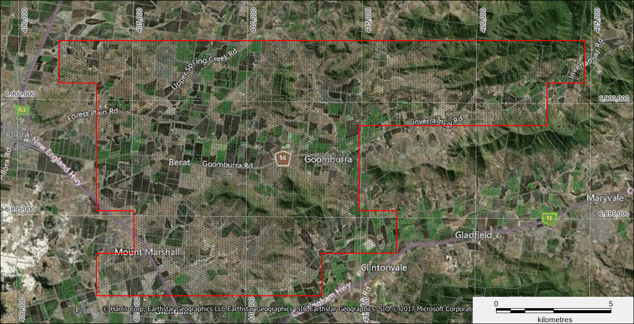
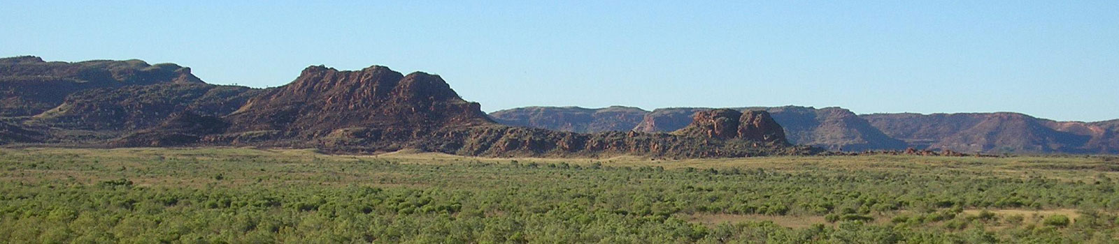
The tenement is adjacent to the junction of the New England and Cunningham highways (Figure 2) with access through the tenements provided by a network of sealed and unsealed roads. The Main Range National Park to the east of the tenements forms part of the Great Dividing Range and is capped by Tertiary basalt lava flows. EPC 1539 is dominated by elevated topography of the main range national park as are small portions within EPC1506 which is dominated by flatter terrain comprising basalt derived soils.
Geology
The tenements are situated in the Triassic to Cretaceous Clarence-Moreton basin, which formed in conditions of predominately fluviatile sedimentation. The development of the Clarence-Morton basin was contemporaneous with the Surat basin and broad stratigraphic units can be correlated between the basins. However, the underlying tectonics and sources of sediment were different, resulting in a differentiation of specific sedimentary sequences. Much of the basin is dominated by the late Triassic to Jurassic Bundamba Group comprising the older Woogaroo Subgroup, a sequence of predominantly conglomerates and sandstones deposited in a fluvial to lacustrine environment. The overlying Marburg Subgroup comprises predominately quartz sandstones interbedded with grey shales and mudstones. All the above geological units occur outside EPC 1506 and EPC 1539.
The Walloon sub group sits conformably on the Marburg Subgroup and represents widespread fluvial and lacustrine to paludal deposition over the entire basin. The sub group consist of siltstone, banded coal horizons or packages and fine to medium grained lithic sandstone, and has been subdivided into the Taroom and Juandah Coal Measures, which are separated by the Tangalooma Sandstone while the Durabilla formation underlies the Taroom coal measures. Coal-bearing “packages”, rather than distinct seams, are common, and this is a result of seam splitting, resulting in several seams with variable thicknesses.
It is noted by Brookes (1982) that within the area of EPC 1506, the Walloon coal measure seams occur typically 40 m–50 m above the Marburg Formation and as such is likely to represent the Taroom coal measures. The individual seams are generally thin (less than 1m) and are high in inherent ash content due to their highly stone-banded nature. Many of the thicker sequences containing individual seams are overlain by thick water-bearing gravels. The Walloon sub group outcrops in the southern portion of EPC 1506 as pale grey quartz sandstone likely of the Tangalooma sandstone.
Deposition occurred within fluvial channels which were relatively stable for extended periods of time, allowing peat deposition with minor interruption by overbank deposits; this geometry is similar to pod shaped lenses. Channel migration has restricted these deposits over large areas.
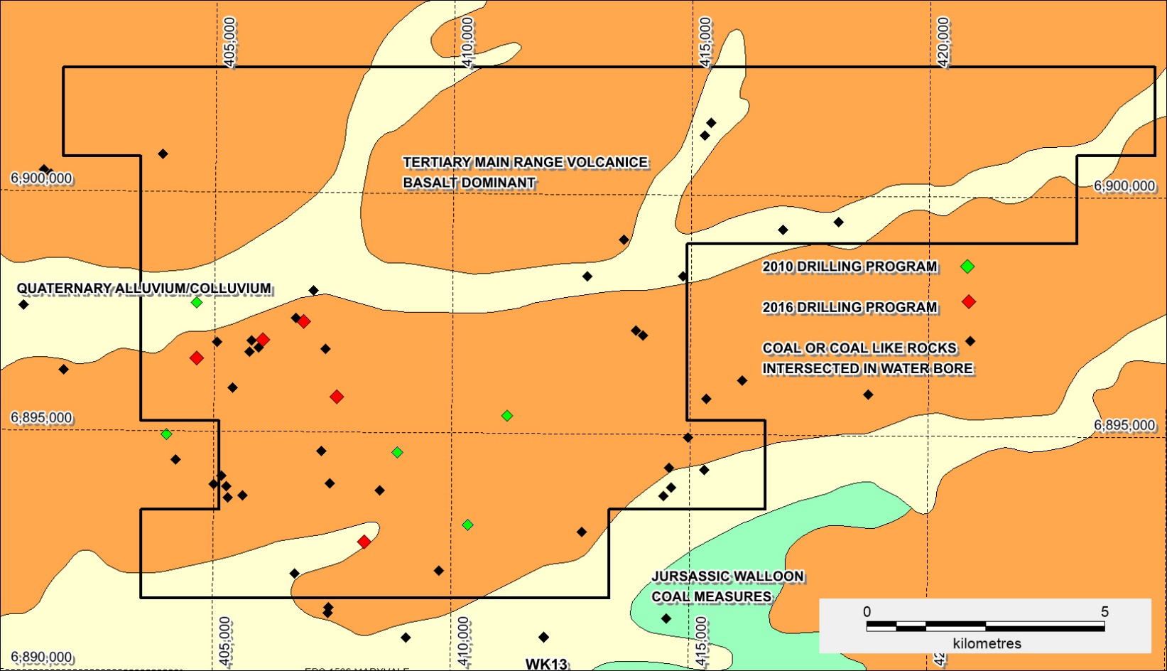
Figure 3 EPC 1506 and EPC 1539 project geology and historical drilling
The high topographic areas are dominated by Tertiary Main Range Volcanics which regionally comprise Alkali-olivine basalt, minor tuff, sandstone, and mudstone. Within EPC 1506 the dominant lithology of the Main Range Volcanics is dark grey vesicular basalt. Quaternary/Cainozoic alluvium and colluvium dominates the current Dalrymple and Glengallan creeks and adjacent flood plains with input from both the current creeks and adjacent basalt covered hills. The resultant soil from the eroding basalt hills has resulted in a fertile growing medium adjacent to the creeks.
Historical exploration
Historical drillhole locations within EPC 1506 and EPC 1539 are shown in (FIGURE 3) and comprise water bores which were drilled to shallow depths of usually less than 50 m and company coal exploration chip and diamond core holes drilled to depths of several hundred metres. Several of the coal exploration drill holes were geophysically surveyed to look for lithological and coal signatures and to be submitted for coal quality analyses in Brisbane. A single petroleum well was drilled to the south of EPC 1506 and has provided broad lithostructural information.
Global Minerals: Of the 48 holes drilled in the area by previous operators, 22 intersected coal. The sub-horizontally dipping Walloon coal sub group was reported to have been intersected beneath Tertiary flow basalt and/or Quaternary alluvium cover. Sample results for five banded coaly intervals returned very high ash contents ranging from 43% to 69% (presumably air dried basis).
Millmerran Coal: No drilling was conducted, with only a literature review of previous drill hole data, water bore data and data from Clifton Colliery located nearby, and that mined coal from the Walloon sub group prior to 1900. The reasons for the tenements being later relinquished were not stated, although Milmerran Coal was later involved in a joint venture (JV) covering the general area.
Millmerran JV: Within the Clifton and Warwick areas of the tenement, a total of 164 open holes and 30 cored holes were drilled by previous operators averaging around 100m in depth. A number of the holes drilled by AMAX (Millmerran JV) intersected the near surface Tertiary Basalt and then the underlying strata. However, some holes (such as WRO0006, WRO0065, WRO0066, WRO0112 and WRO0113) did not penetrate through the basalt and were terminated early.
Drilling results suggested that the coal intersected was in the lower Walloon sub group associated with the Taroom coal measures. A total of 53 laboratory samples were analysed by previous operators. In general, the coal was found to contain high raw ash (typically ranging from 40%-55% adb (air dried basis), high volatile matter, low sulphur, and specific energy ranging from 12-18 MJ/kg (adb). Although coal intersections were occasionally several metres thick (i.e. WRD0001: 4.1m, WRD0031: 3.8m, WRD0070: 3.1m and WRD0073:5.5m), there was a lack of continuity between holes for these intersections (Brooks, P.J, 1982).
Andrew Wright Holdings: While this tenement overlapped both EPC1506 and EPC1539, the drilling was to the north of both tenements and was reported to have intersected “Walloon-type coal”. Most drill holes intersected heavily banded coaly intervals containing numerous claystone lenses and inclusions that were considered to possibly be tuffaceous in origin, although occasional holes intersected seams reported to be several meters thick.
Clean Global Energy: In 2010, Clean Global Energy (“CGE”) commissioned GeoConsult to undertake a drilling program comprising 8 drill holes, 6 open holes and 2 twinned partially cored holes within EPC1506. These holes specifically targeted the Taroom coal measures of the lower Walloon Sub Group in the depth range 100 m – 350 m. Two primary coal seam targets were identified, the Bulwer Seam and the Condamine Seam, with thicknesses typically ranging from 2-3.5m. Other coal intervals were intersected above the Bulwer seam.
Up to 85 waterbores have been completed by previous operators within EPC 1506 and EPC 1539 however the waterbores do not contain wireline density logs and drilling depths were generally less than 70 m. Water bores were reported to have intersected banded coaly sections up to 7.6 m thick and an individual coal seam 2.1 m thick. Water bore information will be used when siting of further drill hole positions.
Resource
The maiden JORC 2012 compliant resource was based on the 2010 and 2016 drilling programs managed by Brisbane based geological consultancy Geoconsult. The resources are outlined in TABLES 3 AND 4
Figure 4 EPC 1506 showing the ISG Inferred Resource and Exploration Targets
TABLE 3: INFERRED (ISG) RESOURCE ESTIMATE
| Resource Polygon | Working Section | Thickness (m) | Inherent Moisture (ad%) | Ash (ad%) | Volatiles (ad%) | Density (RD) | Tonnage (Mt) |
| Maryvale ISG Total | BU31-35 | 2.85 | 7.2 | 47.2 | 25.6 | 1.68 | 97 |
TABLE 4: EXPLORATION TARGET OPEN-CUT AND ISG ESTIMATES
| Resource Polygon | Working Section | Thickness (m) | Tonnage (Mt) |
| Open-Cut Total | BU31-BU35 | 3.3 | 80-105 |
| ISG Total | BU31-BU35 | 2.5 | 90-125 |
Nb. packages lacked sufficient Points of Observations spacing to classify as Coal Resources and are expressed in ranges (lower- upper). Targets are conceptual in nature. The potential quantity and quality is conceptual in nature and there has been insufficient exploration to estimate a resource and it is uncertain if further exploration will result in the estimation of a mineral resource

The 2010 and 2016 drillholes are the central basis of the geological data used in the resource estimate. These holes specifically targeted the Taroom Coal Measures of the Walloon Sub-Group in a depth range of 100m to 350 m and they intersected significant portions of the stratigraphic sequence. The 2016 drilling comprises drill holes WK16, WK16C, WK17, WK18 & WK19 are located within the Goomburra area of EPC1506 with the drill hole locations shown in FIGURE 4.
The typical stratigraphy for the Walloon Sub-Group is shown in FIGURE 5. The geological model has been based on correlation of the well-established stratigraphic units of the Taroom Coal Measures. Correlation across the deposit was based on four stratigraphic units; Tangalooma Sandstone, Auburn Seam, Bulwer Seam and Condamine Seam. The coal seam units were correlated based on slimline geophysical log signatures. The lenticular nature of the Surat Basin coal can make correlation difficult, especially, as in this case, where drillholes are widely-spaced. Several validation passes using cross-section and structure models were used to validate the stratigraphic and ply correlations. The nomenclature used to correlate seams and plies is shown in FIGURE 6. Stratigraphic and ply correlations for the underlying Condamine Seam which was not used in the resource estimates is shown as FIGURE 7.

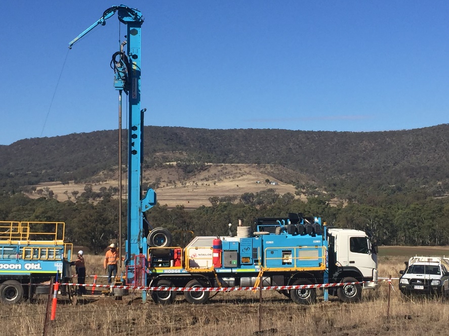
Resource drilling at the Maryvale coal project and a coal intersection from WK16C of the Bullwer Seam.
The cross-sections shown in FIGURE 8 indicate the general structural trends across the project area as well as the Condamine Package (FIGURE 7) which underlies the Bullwer Package (FIGURE 8) across the project area. The Condamine Package has been intersected by historical drilling however there are not enough drill intersections for it to be included in the Exploration Targets.

The primary target within the Bulwer Seam is the BU30 package, which was correlated in detail using a five-ply model, namely BU31-BU35 (FIGURE 7). A ply by ply correlation of a Bulwer package working section from each intersection associated to EPC1506 was completed. FIGURE 6 shows the typical seam profile of the Bulwer package and typical coal quality results for the plies. In 2010, a secondary target, Condamine package (CO70) was also correlated in detail across the area. Correlation of a Condamine package working section using each intersection associated within EPC1506 was completed. FIGURE 7 shows the typical seam profile of the Condamine package along with the typical coal quality results for the seam.
The target for exploration drilling in the 2016 program was the Bulwer package and only drillhole WK16 was drilled deep enough to intersect the upper part of the Condamine package. The Condamine package has not been included in the Resource estimation. Additionally, the Auburn package (uppermost package) has not been considered as viable for deriving Resources and is not included in this modelling report.
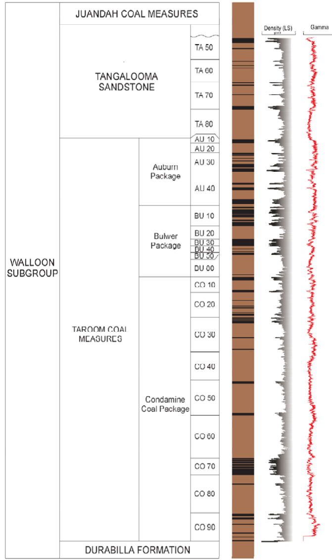
FIGURE 5: TYPICAL STRATIGRAPHY OF THE WALLOON SUB GROUP WITHIN EPC 1506 – MARYVALE COAL PROJECT
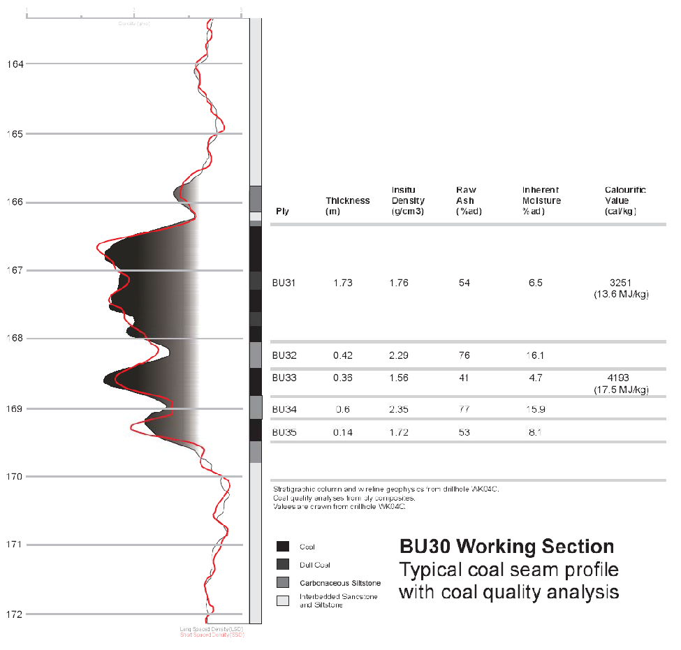
FIGURE 6: TYPICAL PROFILE OF BULWER PACKAGE
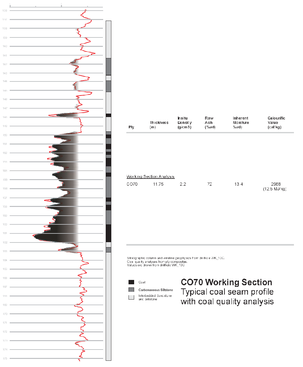
FIGURE 7: TYPICAL PROFILE OF CONDAMINE PACKAGE
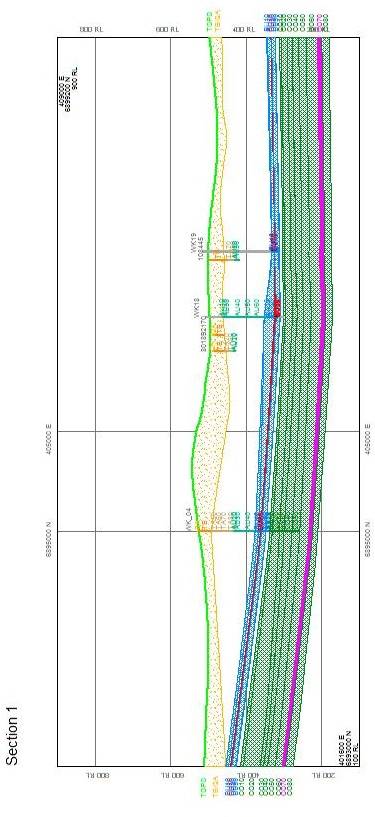
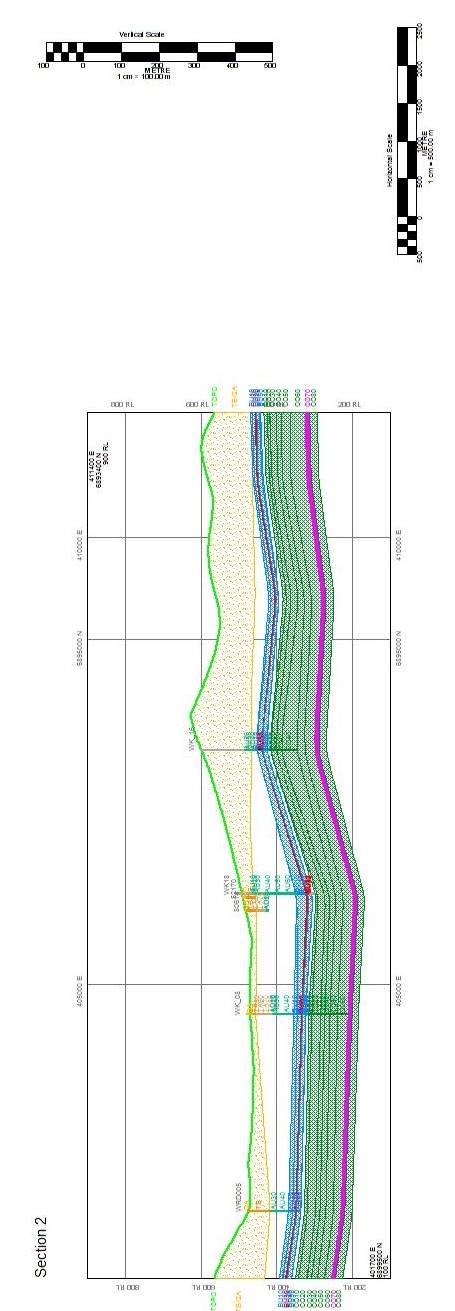
FIGURE 8: MARYVALE COAL PROJECT CROSS SECTIONS-SEE FIGURE 4